MyPest Page -
IPM Pest and Plant Disease Models and Forecasting

  For Pest Modeling in the US for Agricultural, Pest Management, and Plant Biosecurity Decision Support in the US
Introduction:
This website combines US weather and climate data (32,000+ locations) with numerous models to support a wide range of agricultural decision making needs. We currently serve over 130 degree-day (DD), DD maps, 24 hourly weather-driven models, 9 mobile-friendly plant disease infection risk models, and 5 synoptic plant disease alert maps for integrated pest management (IPM), invasive species, biological control, and other uses for the full USA. See a more complete project description here.
Our primary Degree-Day (DD) Model & Calculator Interfaces (see Shortcut Links tab for others):
      
  1. "dd/model_app" our newest mobile-enabled DD model interface
  2. Signup for automated "push" emails of 140+ DD and disease risk models
  3. "MyPest Page" Disease risk, DD, other models (also see Quick Start tab)
Additional Resources:
      
  1. What's new
  2. Online tutorials
  3. Degree-day usage instructions
  4. How-to make webpage bookmarks (technical document #1)
  5. How-to make "mashups" with uspest.org charts and tables (tech. doc. #2)
  6. Frequently asked questions
  7. Related web sites
  8. 2023 and past usage/no. DD model runs
Presentations:
      
  1. Medium- and Extended-Range Weather and Climate Forecasts Scaled and Tested for IPM Decision Support in US States NW Climate Conf., Skamania, WA Nov. 2016 (poster .pdf)
  2. Systems modeling of crop and insect development for agricultural decision support OSU Horticulture Seminar, Corvallis, OR Nov. 2017 (60 min. video)
  3. Weather and Climate Driven Models for IPM and Invasive Species Management 9th International IPM Symposium, Mar. 2018 (poster .pdf)
  4. USPest Push Notification Service Overview Tutorial Aug. 10, 2021 (13 min. video)
  5. DDRP: a modeling tool for forecast insect phenology and risk of establishment Ecological Forecasting Initiative Conference. May 23, 2022 (8 min. video)
Partners and Support:
We are actively collaborating and partnering with Fox Weather, LLC and the National Weather Service for forecasts, with the OSU PRISM Climate group for climate data, with the W. Region IPM Center, the USA National Phenology Network, and with numerous state and private IPM decision support programs and entities. Funding has been provided by numerous USDA NIFA grants (including IPM, Biosecurity, and SARE), USDA PPQ, RMA and ipmPIPE grants, NPDN grants, WR-IPM Center and Oregon Statewide IPM funds, and local and regional commodity grants.


  To configure MyPest Page, select one or more Crops  and enter a Zipcode to initialize settings for your plant disease risk and degree-day models. Then click the "Go" button.
     
Crop(s):  apple pear cherry peach grape
caneberries strawberry hazelnut walnut pecan
nursery wheat oats grains alfalfa
beans hop vegetables potato corn
sugarbeet peppermint sunflower clover
invasive species park&yard trees degree-day calc. only
Zipcode:       
 
Returning user? Go directly to /risk/models - MyPest Page
        (only your previous settings will be used)


    Map Index  to plant disease risk  and degree-day models clickable USA map
Degree-Day (DD) Model & Calculator Interfaces:
(we have various ways to run our list of DD models+calculator)
      
  1. "dd/model_app" newest, mobile version, includes file upload and Celsius options
  2. "dd/model" Google map interface (w/mult. start dates, highcharts, NO Celsius)
  3. "ddmodel.us" Google map interface (older version, w/Celsius option)
  4. "MyPest Page" disease risk, DDs, other models (also see "Quick Start" tab)
  5. Table index of US states and networks linked to models
  6. GIS interface to DD models - see "Degree-day Maps" tab above
Agricultural weather network tables and home pages:
   1. Oregon: Hood River & The Dalles, Medford,
    Milton- Freewater, AgriMet,
    CROPTIME vegetable scheduling homepage
   2. Washington: AgriMet
   3. Idaho: AgriMet
   4. Montana: AgriMet
   5. California: CIMIS, PESTCAST
   6. All States and Networks full index
Plant Disease Infection Risk mobile-friendly "Apps" with email "Push" notifications (sign-up here) and "Synoptic" alert maps. Documented here:
   1. Apple Scab: Mobile App
   2. Botrytis and experimental soybean rust: Synoptic Map
   3. Boxwood Blight: Mobile App (see how to use instructions), Synoptic Map
   4. Cherry powdery mildew: Mobile App
   5. Fireblight: Mobile App, Synoptic Map
   6. Grape powdery mildew: Mobile App
   7. Grass seed stem rust: Mobile App
   8. Hop powdery mildew: Mobile App
   9. Pear scab: Mobile App
   10. Potato-tomato late blight: Mobile App, Synoptic Map
   11. Tomcast DSV: Synoptic Map
   12. Dollar spot: Mobile App
   13. MelCast (Muskmelon): Mobile App
   14. MelCast (Watermelon): Mobile App
Other special Models and Web Pages
   1. Spotted Wing Drosophila ipmPIPE Page
   2. Soil Solarization of Phytophthora spp. for nursery beds
   3. Swiss needle cast 2008 - working once again
   4. Medford Oregon Drift Reduction Tools - includes stream distance calculation
   5. Northwest Degree-Day Info DD accumulations year-to-date for selected locations
1. GIS interface to degree-day model:
                                Size:   Region:   
2a. Home page and directory of selected (D)egree-(D)ay,
establishment (R)isk, and (P)est event maps (DDRP)

   Currently hosting 16 invasive species.
2b. New home page and directory for emerald ash borer in Oregon with interactive Grasslinks interface.
3. New DDRP for weed biological control (custom degree-day maps) for control of Japanese knotweed, purple loosestrife, and tamarisk.
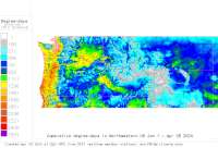
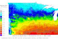
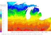
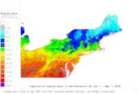
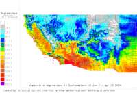
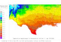
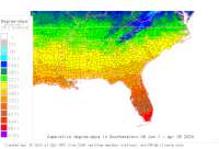
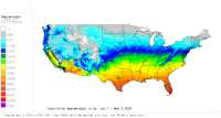
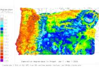
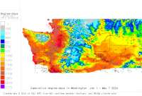
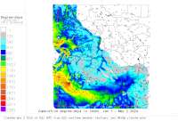
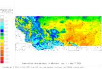
4. Custom degree-day mapmaker for 48 US states - use your own settings (NOTE: TAKEN OFFLINE beginning 2/28/2024):
   A. GRASS Platform (maps up to yesterday; grids, GRASSLinks interface)
   B. NEW R Platform (maps w/forecast to end-of-year; PNG & grids only)
5. Daily degree-day accumulation maps - click on a region for more maps:
Northwestern
daily NW USA DD maps - this year to date
North Central
daily NC USA DD maps - this year to date
Great Lakes Central
daily GL USA DD maps - this year to date
Northeastern
daily NE USA DD maps - this year to date
Southwestern
daily SW USA DD maps - this year to date
South Central
daily SC USA DD maps - this year to date
Southeastern
daily SE USA DD maps - this year to date
48 State USA
US this year to date
Oregon
daily Oregon DD maps - this year to date
Washington
daily WA DD maps - this year to date
Idaho
daily ID DD maps - this year to date
Montana
daily MT DD maps - this year to date
Wyoming
daily Wyoming DD maps - this year to date
Use these maps to track heat unit build-up using the temperature thresholds 32°, 41°, and 50° F, and for GIS interface to calculate degree-days at specific locations.


Oregon IPM Center at Oregon State University The PRISM Group at OSU Western
 Region Pest Management Center Integrated Pest Management PIPE National Institute
 for Food and Agriculture

All data are provided "as is" and users assume all risk in their use - see full disclaimer. See also OSU Disclaimer. See our Data Usage - Terms of Use. All NWS derived data is not subject to copyright protection. This site hosted by the Integrated Plant Protection Center at Oregon State University with support from USDA APHIS PPQ, USDA NPDN, The OSU Agricultural Experiment Station, various USDA CSREES/NIFA grants, USDA RMA, and USDA IPM Centers - Western Region. Climate map data provided by OSU PRISM Group, real-time public weather data provided by U. Utah Mesowest and other networks including WSU AgWeatherNET, AGRIMET, California CIMIS, California PestCast, and others.
This page on-line since April 5, 1996; last update Jan 29, 2024. Contact Len Coop, OSU OIPMC and Horticulture Dept. at coopl@science.oregonstate.edu or 541-737-5523 if you have any questions about this information.