Online Phenology Models and Degree-day Calculator
info GWU Virginia Science & VA  station: 1857W WEATHERSTEM elev: 259 ft  lat/long: 39.0547 -77.4439
  Select location by clicking on pin in Google Map above
 peach twig borer
 [stone fruits]

2007 USU Ext.
immaturedamageadult
  info Model category: 

  Select model: (see list)   (model params) 

  Output in:

  Start:
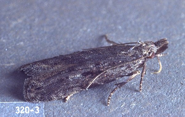
  Starting date instructions: 1st consistent capture of moths in pheromone traps #   (ca. 405 DD after Mar 1 or Jan 1 in warm climates)

  End:  
  Model validation status: requires local validation Region(s): used in NW USA

  info Forecast type: 

Model
preview:


future
events


  info  Output:  Simple header  No table  Graph precip 


[Home] [user survey] [Intro] [US State/Network Index] [DD Map Calculator] [Links]
Oregon IPM Center at Oregon State University IPM PIPE The PRISM Group at OSU Western
Region Pest Management Center National Institute of
Food and Agriculture
All data provided "as is" and users assume all risk in its use - see full disclaimer. All NWS derived data is not subject to copyright protection. This site hosted by the Integrated Plant Protection Center at Oregon State University with support from the USDA National Plant Diagnostic Network, The OSU Agricultural Experiment Station, various USDA CSREES/NIFA grants, USDA SARE, USDA RMA, and USDA IPM Centers - Western Region. Climate map data provided by OSU PRISM Group, real-time public weather data provided by U. Utah Mesowest and other networks including WSU AgWeatherNET, AGRIMET, CPS Adcon Networks, IFPNet Automata, California CIMIS, California PestCast, and others.
Previous versions online since May 16, 1997, this version 5.6, updated Jan 3, 2024
Contact Len Coop at coopl@science.oregonstate.edu if you have any questions about this program.