|
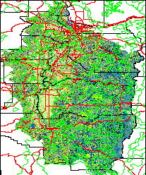
(with county lines, major roads, water bodies, cities
and towns, and degree-day calculator)
|
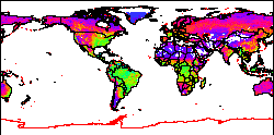
(a small default global dataset for getting familiar with GRASS)
|
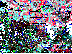
(a default dataset for getting familiar with GRASS)

GRASSLinks is a World Wide Web interface to a geographic information system (GIS), offering public access to mapped information. This is an update of GRASSLinks 3.2 and includes multi-resolution display and other updates since the earlier versions. We will try to make installation easier than prior versions. See also the page gl.html which includes only the two GRASS (global and Spearfish) datasets.
or
| Left side - full selection of available maplayers and options | Right side - shortcut with mostly preselected options | ||
| Willamette Valley, Oregon Land Use 30m (with county lines, major roads, water bodies, cities and towns, and degree-day calculator) | ||
| GRASS Global dataset (a small default global dataset for getting familiar with GRASS) | ||
| GRASS Spearfish dataset (a default dataset for getting familiar with GRASS) |
![]() DOWNLOAD latest version (new fast install script by Roman): glinks_3.2beta3.tar.gz
DOWNLOAD latest version (new fast install script by Roman): glinks_3.2beta3.tar.gz
NOTE: read INSTALL for "QUICK" install docs; not fully tested with GRASS latest versions (grass5.4 is latest fully tested version)
You may also wish to DOWNLOAD preconfigured spearfish.tar.gz and global.tar.gz GRASS databases
GRASSLinks was originally developed from 1994-98 by Dr. Susan Huse at the Research Program in Environmental Planning and GIS
(REGIS), at the University of California, Berkeley. This is claimed to be the first fully funcional online
GIS package offering public domain access to environmental and geographical data.
GRASSLinks is based on the Open Source GIS
software
GRASS, orig. from the US Army Corps of Engineers.