Douglas Fir: Swiss Needle Cast Risk Model - New Version April 2008
A climate and terrain based model of swiss needle cast severity estimated as needle retention

  • Review the GIS data layers that can be viewed, downloaded (only lat-long ARC GRID and SHAPEFILES - May 4, 2008) and analyzed in GRASSLINKS.
  • Preliminary documentation for the 2008 SNC_V4 model: PDF.
  • Download PPT and PDF versions of poster developed for American Phytopathological Society (APS) Annual Meeting, San Diego, CA, July 28-Aug 1, 2007.
    Left side: full selec-
    tion of available map
    layers and options
    Right side - shortcut with mostly preselected options

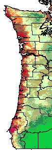
    GRASSLinks GIS Web interface to maps of SNC survey data and climate models:

    Select layers, overlay, mapsize, region, and "GO"
    Query only raster layer #1
    Query only raster layer #2
    Main (only visible) Raster Layer
    NOT WORKING (ignore) Vector Layer
    Region (please match to selected raster and vector layers)
    Optional overlay Mapsize (ht in pixels)