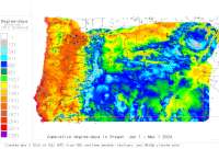
AGRIMET Network - other tables for OR include: All Networks, CWOP/APRS, METAR, see our homepage.
|
Also try the full-featured calculator/DD model (NW states only) |
|
| ||||||||||||||||||||
|
CropTime OSU Weather Data and Phenology/Degree-Day Models AGRIMET Network - other tables for OR include: All Networks, CWOP/APRS, METAR, see our homepage. | ||||||||||||||||||||
| ||||||||||||||||||||
| # | Location click to go to DD model interface |
County |
Station code, links to NWS recent weather |
Links to NWS fore- casts |
Net- work Elev. (ft) |
Lat./ Long. (Dec. Deg.) |
Max-min temperature data and degree-days (click radio button to calc.) |
30 yr avgs |
||||
|---|---|---|---|---|---|---|---|---|---|---|---|---|
| 1 | AURORA | Clackamas |
|
Zone
|
141 | 45.28167 -122.75028 |
2012
|
2011
|
2010
|
2009
|
AVG |
|
| 2 | CORVALLIS | Linn |
|
Zone
|
230 | 44.63417 -123.18972 |
2012
|
2011
|
2010
|
2009
|
AVG |
|
| 3 | Detroit Lake | Marion |
|
Zone
|
1675 | 44.72972 -122.17917 |
2012
|
2011
|
2010
|
2009
|
AVG |
|
| 4 | FOREST GROVE | Washington |
|
Zone
|
180 | 45.55306 -123.08333 |
2012
|
2011
|
2010
|
2009
|
AVG |
|
| 5 | MEDFORD | Jackson |
|
Zone
|
1339 | 42.33083 -122.93778 |
2012
|
2011
|
2010
|
2009
|
AVG |
|
[USPEST.ORG/WEA Home]
[Feedback Survey]
[Intro]
[US DD Mapmaker]
[Main Table Index]
[Links]


|